Centre for Sustainable Development and Environment
English فارسی
Skip to content
  • Themes
    • Nomads and local communities
      • Nomads
        • Abolhassani
        • Bakhtiari
        • Chodari
        • Lor
        • Qashqai
        • Sangsari
        • Shahsevan
        • Talesh and Galesh
        • Torood
      • Local communities
        • Asaluyeh
        • Baluch
        • Qeshm
      • Networks
        • UNICAMEL
        • UNINOMAD
        • WAMIP
    • ICCAs
      • ICCA registry
        • All
        • Desert ecosystems
        • Forest ecosystems
        • Marine ecosystems
        • Rangeland and grassland
        • Wetland ecosystems
      • All news items
    • Agroecology
      • All
      • Agro-biodiversity
        • Evolutionary Plant Breeding
        • Food security
        • GMOs
        • Landraces
        • Plant breeding
        • Seeds law
    • Combating desertification
    • Conservation
      • Camel
      • Cheetah
      • Marine areas
      • Wetlands
    • Sustainable livelihoods
    • Dams
    • Legal aspects
    • Approaches and methodologies
      • Participatory evaluation
      • Participatory GIS
  • Projects
    • List
    • Projects Map
  • Publications
    • Drynet
    • ICCA Consortium
    • Policy Matters
    • All
  • Community
    • Events
    • Bookmarks
    • Network
  • Multimedia
  • About us
    • Presentation
    • People
      • Current collaborators
      • Former collaborators
    • Contact

Approaches and methodologies

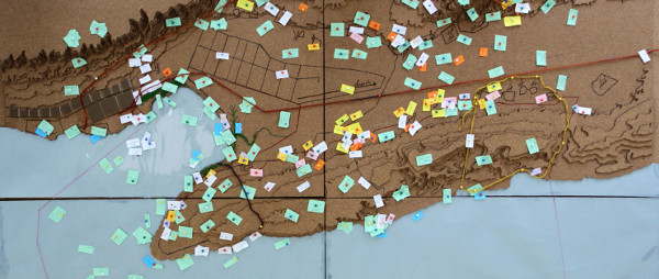
Landmark

Approaches and methodologies, Bookmarks, Nomads, Participatory GIS, UNINOMADNovember 10, 2015
Leave a comment

Participatory zoning of Nayband National Park

Approaches and methodologies, Asaluyeh, Conservation, Events, ICCAs, Local communities, Marine areas, Participatory GISApril 14, 2015
Leave a comment

Video: Map, Territory, Life

Approaches and methodologies, ICCAs, Multimedia, Participatory GIS, Sustainable livelihoods, VideosDecember 31, 2014
Leave a comment

Summit Workshop: Re-empowerment of local and indigenous communities

Agro-biodiversity, Agroecology, Events, GMOs, Participatory GISDecember 25, 2014
Leave a comment

Anzali Wetland Ecological Management Project (Socio-economic Survey Part II)

Conservation, JICA, Participatory GIS, Projects, Sustainable livelihoods, WetlandsMay 1, 2011
Leave a comment

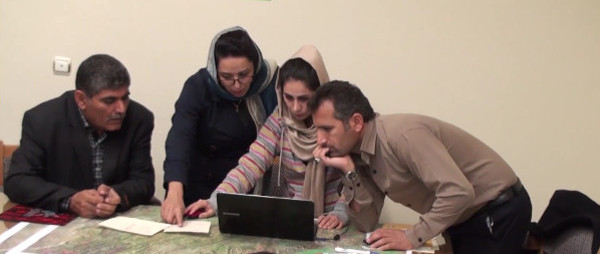
Stakeholder engagement strategies for Participatory Mapping

Approaches and methodologies, Bookmarks, Participatory GIS, Sustainable livelihoodsDecember 31, 2009
Leave a comment

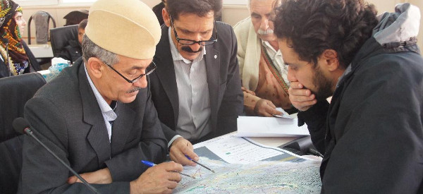
Good practices in participatory mapping

Approaches and methodologies, Bookmarks, Participatory GIS, Sustainable livelihoodsApril 30, 2009
Leave a comment
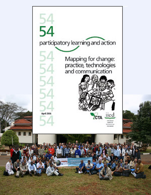
PLA 54: Mapping for Change: Practice, Technologies and Communication IIED and CTA 2006 Multilingual DVD-ROM

Mapping for Change #54

Approaches and methodologies, Participatory GIS, PublicationsApril 30, 2006
Leave a comment

    • « Previous
    • 1
    • 2

About Cenesta

The Centre for Sustainable Development and Environment (CENESTA) is a not-for-profit civil society organisation that struggles to re-empower indigenous peoples and local communities in Iran and beyond (including indigenous nomadic tribes and coastal and marine areas) by promoting and supporting appropriate recognition of Indigenous peoples' and Community Conserved territories and Areas (ICCAs) that emphasise nature conservation, community rights and sustainable livelihoods. CENESTA also promotes democratising agro-ecological research. CENESTA is a member of UNINOMAD (Union of Indigenous Nomadic Tribes of Iran), ICCA Consortium, IUCN and Global Forest Coalition. It is accredited to the 3 Rio Multilateral Environmental Conventions.

No 108, Azarbaijan Street, Tehran
+98 21 66-400-811
+98 21 66-452-741
+98 21 66-452-743
cenesta@cenesta.org

RSS

Entries RSS
Comments RSS

Follow us

Membership and accreditations

Cenesta
27 January 20237 بهمن 1401
✖